


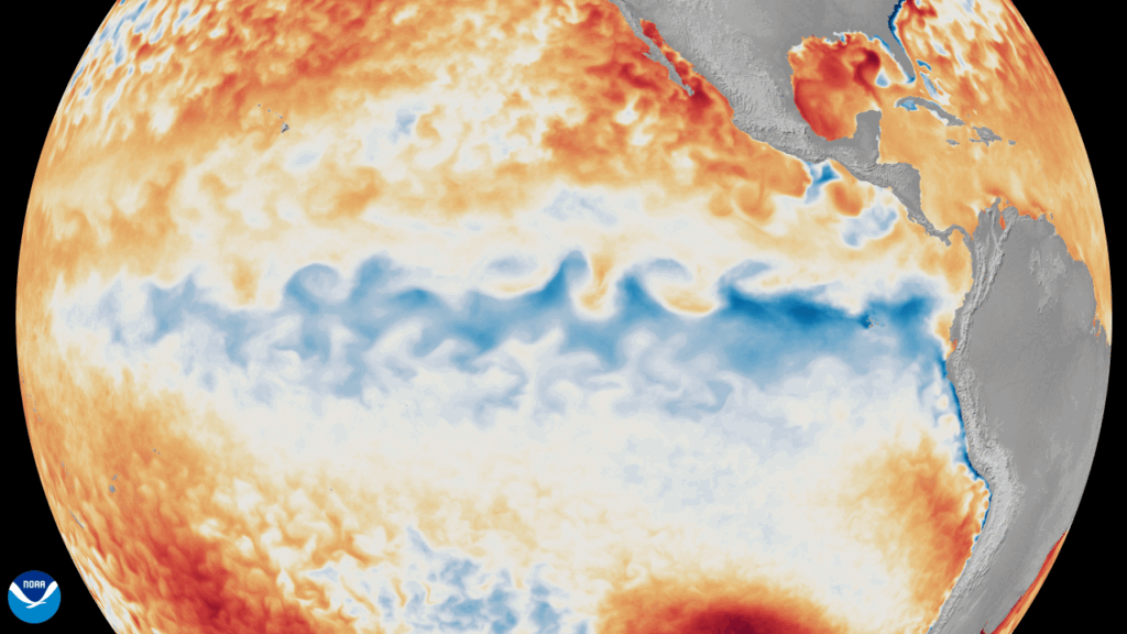
Source: NOAA
Meteorologists have been warning for months of a building “super El Niño” that’s just now getting started.
So, what is a super El Niño?
It’s an unusually intense warming of the tropical Pacific Ocean that can reshape weather patterns across the globe for months at a time. El Niño is part of the natural climate cycle in which sea-surface temperatures and atmospheric circulation in the Pacific swing between three phases: warm (El Niño), cool (La Niña), and neutral. When El Niño becomes exceptionally strong, often defined by a dramatic warming of 3 to 4 degrees Fahrenheit in the Pacific, its impacts tend to be extreme.
Historically, only a handful of events have reached the “super” category, and they are often remembered for major global disruptions. Here are some answers to frequent questions about what to expect from this weather event.
Q:How does a super El Niño change the atmosphere?
A: El Niño doesn’t “cause” a specific storm, but it loads the dice by adjusting large-scale patterns. Key mechanisms include the shifting of upper-level patterns that drive weather systems and reconfigured jet streams that bring increased storminess to some areas — and drought to others.
Q: How will it affect hurricane season this year?
A: A strong El Niño can influence tropical cyclone basins differently. El Niño often increases upper-level westerly winds over the tropical Atlantic, boosting wind shear that can suppress hurricane formation and intensification (meaning would-be hurricanes blowing in from the east do so against headwinds). That said, the Atlantic can still produce destructive storms in El Niño years. Local ocean warmth and short-term patterns can overcome the background signal. In the Pacific, the pattern typically becomes more favorable for hurricane activity, often shifting formation regions and tracks.
Bottom line: El Niño is a meaningful seasonal factor, not a guarantee.
Q: Why does this El Niño seem so disruptive, and how will it impact North Carolina?
A: Even though El Niño is natural, today’s climate background is warmer than it used to be. That matters because warmer oceans fuel more storms, and a warmer atmosphere holds more water vapor, which can amplify rainfall rates when storms do form. This doesn’t mean “El Niño causes climate change,” but it does mean El Niño events play out on a different baseline than decades ago.
In North Carolina, a super El Niño most often shows up in early winter by shifting the jet stream, so storm systems track across the Southern U.S. more often. Winter weather conditions we can expect are:
- Wetter: Higher odds of frequent coastal lows and flooding episodes, though not constant rain.
- Milder: Fewer prolonged Arctic outbreaks, especially compared to La Niña winters.
- Snow is “boom-or-bust”: Seasonal snowfall often ends up near normal, but there’s a higher “big storm” potential if a coastal low teams up with a cold-air damming wedge in a classic North Carolina setup.
- Severe weather: Cool-season severe risk can be higher than average with more Gulf moisture and stronger jet dynamics.
- Spring carryover: If the pattern persists, early spring can stay unsettled and wet.
What is Super El Niño?

About the Author
Share Your Thoughts
Have a question about this story or just want to share what you thought? We’d love to hear from you!
Related Stories
View All
Materials Supply Co-op Marks 50 Years of Service
TEMA has helped co-ops manage costs since 1976

NC Youth Tour ’26 Scrapbook
Take a look back at the unforgettable moments of the 2026 NC Youth Tour

Electric Co-ops Awarded Grant Funding to Strengthen Grid
Grant funding will help electric co-ops build a stronger, more reliable grid for rural communities

NC Electric Co-ops Partner with Veteran Career Program
NC co-ops are connecting military veterans with meaningful careers through The Honor Foundation